

Story contributed by Meg McGuire
Water will have its way, but so will the voice of Eastwick, a proud community battling to be heard.
Eastwick is one of Philadelphia’s smaller neighborhoods (pop. 5,800) and the southwesternmost. Predominantly African-American, it borders Philadelphia International Airport, the John Heinz National Wildlife Refuge, I-95 and the city line with Delaware County at Cobbs and Darby Creeks.
It’s historically marshland and the lowest-lying area of Philadelphia. Decades of flooding in Eastwick has mostly been caused by the confluence of those two creeks and from storm sewer overflows.
Now, and in the future with sea level rise, high tides on the Delaware River will likely contribute to the problem, as will rising waters on the tidal Schuylkill River.
Another contributing factor is the result of an ambitious urban renewal project in the 1950s and ’60s. The marshy low-lying terrain of Eastwick required massive amounts of fill and new drainage infrastructure, but these interventions have proven to be insufficient to address the area’s chronic vulnerability to flooding.
Numerous studies over the years have brought few tangible results until recently, when the community partnered with the city, including the Office of Emergency Management and the Office of Sustainability, to inaugurate an online flood monitoring map.
Flooding has been a constant problem. Archival photos give evidence of flooding throughout the 20th century, most notably Hurricane Floyd in 1999, which produced flooding over five feet in the so-called “Planet Streets”: Saturn Place, Venus Place, Mars Place and Mercury Place, the nearest streets to the creeks.
The most notable recent storms that caused flooding:
Tropical Storm Charley 2004
Tropical Storm Lee 2011
Tropical Storm Isaias 2020
Tropical Storm Ida 2021
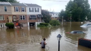
Flooding in Eastwick in 2020. Photo by Gordon Branham
Less extreme flooding can and does happen when there is heavy rain. Continuing development upstream on both creeks means that water rushes across paved surfaces and into the creeks, which then rushes downstream and into Eastwick.
First Street, a company that analyzes flood risk, supplies this forecast:
The neighborhood of Eastwick has a major risk of flooding over the next 30 years. There are 1,536 properties in Eastwick that have risk of flooding over the next 30 years. This represents 90.3 percent of all properties in Eastwick.
A quick drive through residential Eastwick reveals tidy row homes, with no evidence of the degradation usually caused by flooding. In severe floods, all of Eastwick can be flooded. In smaller floods, it’s usually limited to those Planet Streets.
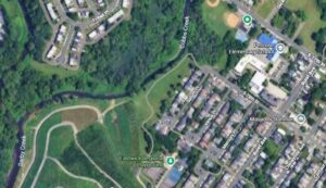
From Google maps, you can see the small, flat green area just behind those streets, and the nearby confluence of Cobbs Creek with Darby Creek. The now closed Clearview Landfill is also visible, its imposing bulk adding to the difficulty of overflow waters going anywhere but the homes of Eastwick.
A distinctive Eastwick voice was likely born when the place got its name in the 1950s — a name bestowed by city planners as they carved up the city during its urban renewal. That process moved the people who were actually living in the “before Eastwick” community — commonly called the Meadows — and relocated to Eastwick mostly Black families from other parts of the city.
As part of that plan, the city sold to Korman Company — a development company — an option to purchase a 128-acre parcel of land adjacent to the John Heinz National Wildlife Refuge, which is a downstream neighbor of Eastwick.
Korman didn’t exercise its rights to that property until 2012 when it proposed to build a 722-unit rental apartment complex with 1,034 parking spaces on 35 acres of the parcel, near South 86th Street and Lindbergh Boulevard — and much closer to Eastwick than the refuge.
By that point, Eastwick found its voice in the Eastwick Friends and Neighbors Coalition, which argued that a plan to build more housing right next to Darby Creek would cause more flooding of more homes.
Long story short, the proposed development was halted.
The Clearview Landfill was also the target of the Eastwick Friends and Neighbors Coalition and the more recent Eastwick United CDC. Community activists forced the closure of the open landfill in 1973 and demanded that the Environmental Protection Agency (EPA) analyze what sort of toxins were in the landfill threatening the neighborhood. Eventually in 2001, the EPA placed the landfill on the Superfund’s National Priorities List,
The EPA then worked with the community to determine what sort of cap would address its concerns. When the EPA covers or caps a landfill, the caps isolate the contaminants to avoid the spread of any toxic contaminants into the air or ground water.
The community agreed to an “evapotranspirative” cap, which involved using plants that naturally suck up water with their roots and release it through pores in their leaves. The cap also minimizes the amount of precipitation that could filter through. The cap was completed in 2023.
After lots of negotiations, the site was rehabilitated in a way that made a not-too-great neighbor — the landfill — slightly better.
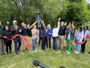
Eastwick residents and members of the city’s Office of Emergency Management celebrate the kick-off of the new flood monitoring system. Photo by Meg McGuire
You pass by that landfill when you enter Eastwick Regional Playground, which was the site of a ribbon-cutting in early May, on Eastwick Community Day — now in its fourth year and hosted by the city’s Office of Sustainability.
There was a buzz of excitement because the city worked with the community to create an online Flood Monitoring System that was accessible anywhere and that provides 16 venues in the city with an up-to-the-minute view of flood-prone streets.
The theme of the celebration was the promise from Philadelphia’s Managing Director Adam Thiel: “We are not done.”
And a resident of Eastwick, Brenda Whitfield, echoed that phrase and praised the city for its efforts.
The promise seems to have been fulfilled.
In addition to the Flood Monitoring System, the city will be installing a temporary levee called a HESCO barrier to serve as an interim barrier to mitigate moderate flood events until a permanent U.S. Army Corps of Engineers levee is constructed.
And in March 2026, the city’s Office of Sustainability released its Eastwick Flood Resilience Strategy. The voice of Eastwick is prominently recognized: The report’s co-author is the Flood Mitigation Council of Eastwick, a 10-member board composed of Eastwick residents.
Its analysis outlines ambitious undertakings that will need support from local, state and federal governments, as many of the solutions are expensive.
Here’s how the report outlines its purpose:
Prior to the Eastwick Flood Resilience Strategy, there was no comprehensive review and prioritization of the possible flood resilience projects for Eastwick. While some projects were explored in isolation, including the Cobbs Creek Levee by the U.S. Army Corps of Engineers, and Nature-Based Solutions by Heinz, the projects lacked a coordinated and ongoing approach to reducing flood risk from all sources of flooding across Eastwick.
The voice of Eastwick will continue to be heard.
